Parks within Bull Valley
More parks and conservation areas in Bull Valley
Visit the Parks Department for Bull Valley Dog Park
The Land Conservancy of McHenry County (TLC) is an organization that works with private landowners to help them preserve their property with donated conservation easements. To learn more, visit: https://conservemc.org
The following conservation easements are located in Bull Valley.
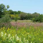
Boloria Meadows, Bull Valley —
Today, it is a challenge to find undiscovered natural areas tucked away behind the curtains of invasive brush and trees found along so many of our roadways. But these natural treasures do exist, and this is one such place. Named after the genus of silver-bordered Fritillary butterfly, Boloria Meadows has winding nature trails that lead through high quality prairie, sedge meadow and oak woodland ecosystems that abound with seasonal wildflower displays.
Wolf Oak Woods, Bull Valley —
Wolf Oak Woods is named after the Wolf Oak – a large, open-grown bur oak with limbs that spread out and, overcome with their own weight, swoop down to touch the ground and grow back up again. The Wolf Oak tree, clearly visible from a major highway in the county, has become a cultural icon and ecological relic. Beyond this tree, the preserve includes 30 more acres of ecologically intact wetland and oak woodland. Volunteers have been clearing this site at Wednesday morning workdays to free up more sunlight for the carpet of spring ephemerals and wildflowers, such as Dutchman’s Breeches and Shooting Star. A prairie has also been planted near the Wolf Oak to create beneficial habitat for our pollinators.
McHenry County Conservation District owns or manages 25,754 acres of open space and provides wildlife habitat preservation, educational opportunities and recreational amenities for the citizens of McHenry County to appreciate and enjoy. To learn more about MCCD, please visit their website: https://www.mccdistrict.org
The following MCCD parks are located within Bull Valley.
Boone Creek Conservation Area —
Boone Creek offers a 2 mile hiking trail and 1.3 mile local horseback trail link, as well as opportunities for picnicking on the observation deck and wildlife watching through viewing scopes. Situated in the upper reaches of the Boone Creek watershed, the 608-acre Boone Creek Conservation Area protects the headwaters, upland recharge areas, wetlands and creek corridors of the greater 13-mile Boone Creek.
The Boone Creek watershed drains roughly 23 square miles of McHenry, Greenwood, Door and Nunda Townships. Seeps and springs from the surrounding hillsides flow year round into the valley that forms the stream bed of Boone Creek, one of the highest quality streams in Illinois. And, within the watershed, over 1,000 acres have been protected thanks to a consortium of state, county, local organizations and passionate residents. Additional protection comes through the Illinois State Nature Preserve, The Land Conservancy of McHenry County, Illinois Department of Natural Resources and private conservation easements.
To date, several known state endangered animal species are protected from having their habitat developed at Boone Creek Conservation Area including the American Bittern, Black-Crowned Night Heron, Osprey, Forster’s Tern, Upland Sandpiper, Blanding’s Turtle, the Slippershell Mussel and the state threatened Black-billed Cuckoo.
History Aerial photographs taken in 1939 show the site scattered with oak trees and a vast majority of the interior of the site composed of a large wetland complex. The meandering creek was shown to be ditched and straightened with agricultural practices taking place on the majority of the site. Fields were plowed and planted along the north and eastern edges, grazing was evident amongst the oaks and hillsides that were too steep to plow, and a series of ponds were dug off Cold Springs Road on the northern quarter. During the 1960s–1990s the area became home to the Bull Valley Hunt Club, a family-owned private club. To accommodate the hunt club clientele, wetlands were dug, diked and dredged to create large water impoundments. Uplands were managed for pheasants, dove, goose and whitetail deer hunting, while ponds, although less than 3 feet deep, provided fishing opportunities.
Today, Boone Creek Conservation Area is comprised of a number of parcels that were purchased by the Conservation District from 1999–2009, funded in part by an IDNR Open Lands Trust Grant Program and an Illinois Clean Energy Community Foundation Grant.
In 2009, the District began a Master Plan process which involved mapping, natural resource data collection, onsite observations and input from neighbors, public, staff, trustees and the Illinois Nature Preserve Commission. A site plan was created that balanced the need to protect the vital natural resources as well as the need and desire for educational and recreational amenities. On June 22, 2013 Boone Creek Conservation Area opened to the public offering an array of recreational opportunities including hiking, picnicking, birding, wildlife viewing and a horseback riding trail.
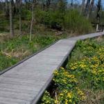
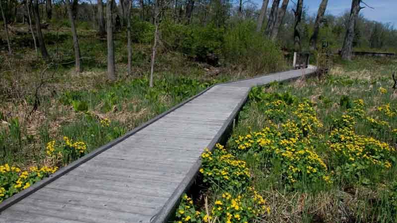
Boger Bog Conservation Area —
This intimate 38-acre site features a one mile nature trail with interpretive signs along a 300-foot boardwalk describing the wetlands communities and the plant and wildlife aspecies they support. The boardwalk was designed and built using green technology, which left the existing patterns of surface and groundwater undisturbed. A council ring provides a natural gathering place for visitors or small groups to pause and enjoy the natural setting and views of a fen on one side and a woodland on the other. It is also the perfect place to enjoy a picnic lunch and observe the wildlife. An ADA accessible picnic shelter and restrooms are also available on site.
Not truly a bog (an acidic wetland community) but more of a graminoid fen (a grass-dominated alkaline wetland community), the site is comprised of numerous natural communities including a silt-loam prairie, calcareous seep and spring, an oak woodland and sedge meadow. The fens support calcium-loving plants like big and little bluestem and Indian grass, and provide habitat for frogs and turtles. An oak woodland also exists on site that sits a top a moraine and is dominated by red and white oaks that provide sanctuary for deer, turkeys, raccoons, possums and birds.
History Frederick C. Boger purchased 38 acres of land in Woodstock in May of 1955 with money he earned singing in his church choir. This parcel of land served as a quiet place of retreat from the hustle and bustle of city life for over 40 years. When Boger passed this land to the District in 1999, he had two simple requests: that the land would be named “Boger Bog” and that it would be open for the public to enjoy as much as he had enjoyed spending time there. Following nine years of restoration as well as design and construction, Boger Bog opened to the public in the summer of 2008.
Visitors to Boger Bog can not only connect with nature as they walk through the site, but also with the history of the land. Mr. Boger collected a lot of interesting materials that the District tried to incorporate into the final design of the site; terra cotta tiles that are presumed to have come from the Chicago World Fair in the 1930’s were used on the roof of the shelter, and the granite cobblestones that make up the council ring and shelter columns came from the old streets of Chicago.